


MapMechanics, the one-stop shop for logistics optimisation solutions, geographic information systems (GIS) and mapping data, including the market-leading TruckStops routing and scheduling system, is enjoying a period of major growth, with customers in the UK and around the world in such diverse sectors as food and drink, pharmaceutical, timber, debt collection, service technicians, building supplies and horticulture.
 Operating from offices in Brentford, Middlesex and Clearwater, Florida, MapMechanics has over 25 years’ experience providing map-based solutions to users from niche specialists to major operations, who all enjoy improved efficiencies and other tangible business benefits.
MapMechanics offers a complete range of map-based technologies including GIS analysis software, drive-time matrices, road speed and map data, together with optimisation applications from site location analysis and network planning to depot territory management, routing and scheduling. Products authored by the company include the TruckStops family of routing and scheduling solutions and OptiSite network planning and territory management module. Together with GIS map data and software sourced from leading originators around the globe, this breadth ensures MapMechanics’ customers always have the best possible solution for their needs.
MapMechanics continues to develop its product range as technology evolves, and is currently rolling out its latest TruckStops release (version 20), to end users worldwide. The long list of TruckStops users here in Europe includes Alliance Boots, Welsh Water, Nightfreight (part of DX Group), Saint-Gobain Glass solutions, Dukes Bailiffs, Cormar Carpets, Sud Ouest (the French newspaper group), Spicers office supplies and Richard Burbidge timber supplies.
Theresa Barlow, General Manager at MapMechanics, spoke to Warehouse & Logistics News.
Warehouse & Logistics News – First of all, Theresa, what does your role as General Manager involve? Are you personally involved in developing tailored solutions for individual clients?
My role is primarily co-ordination within the business, helping our sales, marketing and technical teams work together to provide the best possible service for our customers. I also have specific responsibility for marketing and sales in the logistics team, which includes helping to ensure our solutions are tailored to the client’s precise needs.
WLN – Who are the other key people?
Mary Short, founder and Logistics Sales Director, Chris Greenwood, MD, Paul Dawsey, Head of Operations and David Cockrell, Head of GIS and data sales.
WLN – You serve clients in a wide variety of industry sectors. In which sectors is adoption of your solutions growing fastest?
Food and drink continues to be one of our biggest growth areas and we work closely with dairies and other food producers operating to tight deadlines, who benefit from the operational efficiencies our products help them achieve. Some more niche markets are also growing, for example plant nurseries and greenhouse growers. Sometimes users are not moving goods at all. We are finding growth in any sector that has complex criteria to take into account when planning routes, such as field forces where individuals have specific skills. They are increasingly choosing TruckStops to ensure the best allocation of staff to specific calls while optimising the route to control costs.
WLN – We last spoke to Mary Short in May 2013. How have things been for MapMechanics since then?
We’ve been enjoying a period of major growth since the recession, and we’re expanding our sales, technical and technical support on both sides of the Atlantic to meet the increased demand. We have invested strongly in product development and are reaping the benefits with not only new versions of TruckStops, but also new data products such as street maps for ORACLE systems including ORACLE Real-Time Scheduler and a catalogue of products on the Microsoft Azure Marketplace website for those wanting to develop their own solutions.
WLN – Can you tell us about your US operation?
The US market is reacting enthusiastically to the new modernised TruckStops product. Our Logistics Sales Director, Mary Short, splits her time evenly between the US and the UK and is working closely with a number of US resellers and providers of complementary technologies such as tracking and Transport Management Systems (TMS). For example, Next Generation, authors of the Freightmaster TMS have now embedded TruckStops fully within their product. The TruckStops routing engine generates the same efficient schedules as the standard version, but the user can access it seamlessly through the FreightMaster TMS interface. For end-users, we have established a sales office and technical support service in the States dedicated to our North American customers. We are also building a number of close integrations with ERPs, for example PlantPartner.
WLN – Which are your most important other markets?
Australasia is our next largest key market, with key customers such as Goodman Fielder Bakeries (see case study opposite)
WLN – What products do you offer here in the UK, of particular interest to warehouse and logistics professionals?
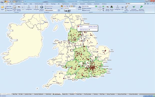
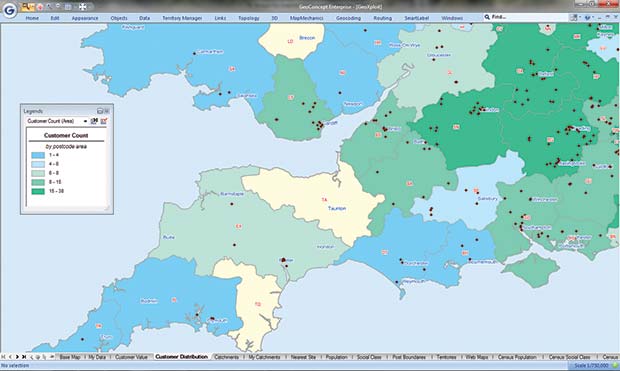
There are three key types of product: Mapping analysis, network planning and routing and scheduling solutions. GeoXploit enables users to clearly map customer distribution and other performance indicators to analyse gaps and trends in the operation. Simple territory management can then be undertaken within GeoXploit, but for more sophisticated call to depot allocation, or to determine the most cost effective locations or numbers of depots, our OptiSite network planning tool is ideal. OptiSite algorithms can handle complex scenarios such as three tier modelling (e.g. factories, regional distribution centres and customers) and take depot capacity into account when calculating a solution. Finally, MapMechanics offers a whole suite of routing and scheduling solutions to meet a wide range of scenarios, e.g. single depot or complex trunking and tramping, own fleet operations, outsourced to 3PL, or a mix of in-house and external carriers.
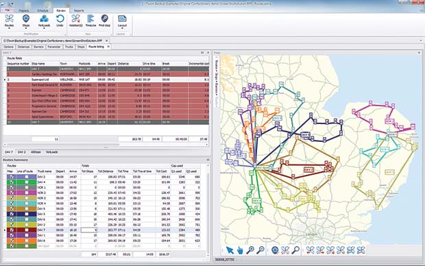
WLN – Routing and scheduling is of particular interest to WLN readers. Can you talk us through the TruckStops product range?
TruckStops VRS is a package that enables end users to optimise every stage of their routing, from planning and scheduling to live reporting and analysis afterwards. It includes multi-depot, multi-route optimisation software, mapping, implementation and support, so users have everything they need to start making savings immediately. For smaller operations, TruckStops Intro offers the same package at half the price for a single depot, small fleet operation. TruckStops International and TruckStops US use the same proven core TruckStops engine, but with mapping and geocoding licenses for the relevant geography. TruckStops supports Unicode characters in both the user interface and data structure, making TruckStops International a strong contender for use in a country’s local languages such as those in China.
WLN – Last time we spoke to Mary, you were developing TruckStops. Now you’re rolling it out to end users worldwide. How does it differ from before?
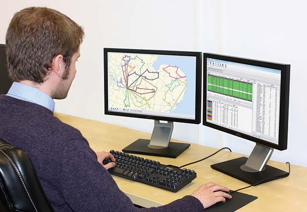
The previously announced new intuitive interface with easy record sorting, selecting and editing; enhanced links to other systems; dual-monitor support and great report writer have been well-received by users. Summing up the new features, one user commented: “planning is now easier and decisions are quicker to make.” Little features make a big difference, such as the one click to open and edit a TruckStops file in Excel, and displaying the tabular solution record and corresponding line of route on the map in the same colour for intuitive cross reference. In addition, every copy of TruckStops VRS or Intro now includes licenced Internet access to the HERE (formerly Navteq) platform, which offers on-line street level mapping, geocoding and aerial photography inside TruckStops.
WLN – What are the benefits of direct access to Internet mapping compared with holding data locally?
The street maps are regularly updated and the HERE service includes aerial photography. So now when geocoding a location which covers a large area and has an entrance away from the centre of the postcode, a user can switch to hybrid map and display the aerial photo under the road network, then simply drag the call point to the most appropriate place. TruckStops will then update the coordinates for that stop and use the new position. To help the driver, reports can include maps around each call point and optionally also include aerial photo backdrops. The Internet also makes it possible to access live traffic information. However, we are aware internet access can be interrupted, so every copy of TruckStops VRS also includes a locally held map and geocoding file, so planning need not be delayed. The best of both worlds!
WLN – You also offer something called TruckStops Loads. What does that do?
TruckStops Loads is designed specifically for “collect and deliver” operations including trunking, tramping and other bulk movement. Sometimes it is used for part-load and full-load operations, however, it is also used for very local applications such as collection and delivery of documents and small packets.
WLN – How have your solutions developed to reflect the increasing use of tracking and mobile devices?
Increasingly we link our products to our customers chosen mobile technologies; from rugged PDAs and tablets to smart phones, CANbus or other on-board devices. Many organisations have also invested in their preferred tracking systems and so MapMechanics offers options to link with these, for example users might want to “get from tracking” (i.e. show the tracked snail trail inside their TruckStops) or “send to tracking” (i.e. send the sequenced points from TruckStops to their tracking site). We facilitate both or either, depending upon the tracking system chosen and customer preference.
WLN – Another trend in business is for everyone to want integrated, seamless, joined up information. What are you offering in response?
Data can be taken directly from the user’s own systems (e.g. TMS, ERP) into TruckStops where routes are optimised. The schedule can then be sent to the user’s chosen tracking system and drivers’ handhelds and, of course, back to the original user databases. Perhaps one of the most interesting aspects is our ability to allow users to see “plan vs. actual” data. Working with tracking partners we are able to show both the planned stops and what the driver is actually doing. The user can use geofences (catchments around each drop) to alert the planning office and or customer in real time, when a driver nears a stop and users can also compare the actual inter-call times and distances with plan, enabling distance matrices updates as required.
WLN – You have a very broad customer base. To what extent can your solutions be tailored to meet different organisations’ needs?
Every copy of TruckStops comes with implementation assistance to tailor the product to the company’s specific needs. One of TruckStops’ key benefits is its superb flexibility. In TruckStops, we have a huge range of configuration options that can easily be set to make complex scenarios seem simple. Perhaps jobs need loading in a specific order, vehicles need cleaning before re-dispatching with different product, you need to plan multi-day routes, or you need liveried vehicles for specific jobs. TruckStops can easily handle most requirements and if there is something we can’t do in the standard product, our development specialists will determine the most cost-effective way of adapting the system to meet the user’s needs.
WLN – Can you give some examples of how different customers use your technology to plan their journeys better?
Every customer uses TruckStops differently. A milk delivery company, for example, found vehicles in a given area were going out full one day, but were only lightly loaded on the next. They told us that by changing delivery day they could improve efficiency, and do more work with the same fleet size. They also use it for finding potential depot locations, modelling a new depot anywhere in the network, and looking at the delivery cost implications. For others, such as Nightfreight (part of DX Group), TruckStops is used to tighten delivery windows. Their director told us the accuracy of their delivery time window is down to TruckStops. For Dukes Bailiffs the time saving was key: MD Colin Naylor said he can save each bailiff at least an hour a day. In the past it sometimes took their planning manager all day to work out journeys for all the bailiffs, but now the job takes just an hour. For many of our users it is efficiency and customer service combined that is key: Cormar Carpets were able to raise the average number of drops per load from eight or nine up to thirteen, yet improve service levels at the same time. They are now achieving at least 98 per cent on-time delivery performance.
WLN – What kinds of ROI can your solutions achieve?
New users have reported cost savings of 10-30% and planning time reductions of 40-50%, but there are other less obvious benefits. Customer service can benefit hugely, such as when TruckStops enables organisations to offer tighter time windows with greater certainty. Where drivers deliver and merchandise, TruckStops’ improved efficiencies can incentivise them to work hard, paying dividends in cost savings and improved sales.
WLN – Do people buy your products outright, or buy fixed term licenses? Do you offer rental versions of any TruckStops products?
Most of our products are offered with a choice of monthly rental or annual licenses, including technical support and maintenance.
WLN – What are the steps to having a MapMechanics solution? How long does it take from initial conversation to going live?
We usually have a detailed discussion to understand the KPIs the client wants to achieve and the details of how their company operates so we can identify specific criteria that need to be taken into account. We generally look at some of their own data and then agree milestones and deliverables. Implementation time depends on the project size and complexity and the customer’s preferred roll out plans, so it can range from a few days to months for large scale multi-phase bespoke developments.
![]() WLN – Finally, where do you see MapMechanics going from here?
WLN – Finally, where do you see MapMechanics going from here?
We will continue our philosophy of collaborating with other organisations to ensure our customers can make the most of all the different complementary solutions that they invest in, providing truly joined up systems that deliver tangible business benefits.
MapMechanics
Tel: 020 8568 7000
EMAIL: INFO@MAPMECHANICS.COM
Comments are closed.