 In addition to the renowned TruckStops routing and scheduling system, MapMechanics offers a wide range of innovative off the shelf and bespoke solutions for map-based analysis and territory management, for use in logistics planning, sales and marketing, and increasingly in the important area of location planning for warehouses and other industrial facilities.
MapMechanics supplies a strong set of territory optimisation and mapping systems designed to enhance any business process with a geographic component. Its GeoXploit Logistics and OptiSite are map-based analysis tools that can either be used independently or linked to routing and scheduling solutions such as TruckStops VRS.
MapMechanics has been expanding rapidly in recent years both here and around the world. Clients as diverse as supply chain solution providers, manufacturers, milk co-operatives and real estate companies use MapMechanics solutions to optimise logistics operations and evaluate warehouse locations. Mary Short, MapMechanics’ Chairman and Business Development Director, spoke to Warehouse & Logistics News.
WLN – Mary, we last spoke in 2010. What’s been happening in the business since?
The single biggest development is that in December 2010, we acquired the Intellectual Property Rights for TruckStops and OptiSite, and thousands more existing licences were assigned to us. We now have total control over these products, enabling us to undertake further development which will continue to embody all the functionality of the existing products, while gaining a range of new features to take the systems into their next generation.
Also since we last spoke to you, we have launched www.TruckStopsRouting.com, a dedicated site for logistics professionals and www.allmapdata.com, a separate e-commerce site for maps, speeds, and traffic restriction information – hazardous materials, maximum heights or weights – together with demographics and postcode data.
In the same timeframe we have expanded our work force and our office space in Brentford, West London.
WLN – That all sounds very positive. What effect, if any, has the recent downturn had on your business?
 We’re very much aware of the downturn, and appreciate that budgets have been cut. In difficult times, efficiency is more important than ever and our turnover for optimisation systems has grown, as we help our customers make savings, provide better service and generate more revenue. In the current climate, everybody in a job is incredibly pushed for time, so we have also noticed more companies asking us to operate the software for them, yet they can still direct the work themselves.
WLN – I gather from our previous interview that MapMechanics began life as Kingswood Ltd in 1987. Do you have any plans to celebrate the business’s 25th anniversary this year?
We plan to celebrate by looking forward, so we are holding a technology forum at the British Library on March 22nd to showcase the latest advances in map-based software, routing, territory management solutions and digital map data. This is a great occasion to share ideas.
WLN – What does your role involve these days?
My role involves developing our longer-term strategies, which sits well with my other focus, business development. Increasingly my job also involves working with our international customers and developing our products to continue to meet the demands of both the UK and world markets.
WLN – Do you get personally involved with developing solutions for individual customers?
Yes, I do. I’m actively involved in forging MapMechanics’ relations with customers and third parties, and look after a number of clients personally. These relationships help provide vital feedback for development of our new solutions.
WLN – You mention customers and third parties. How do you supply your solutions: direct or through distributors?
We sell directly, through value added resellers and via collaboration with specialists who are either expert in their own field or understand the characteristics of their particular territory.
WLN – Do you do much business overseas?
 Yes, we do substantial business overseas. This ranges from digital mapping to full routing scheduling systems with territory management and map analysis. We have clients in all parts of the globe.
WLN – How does the UK compare with other countries as a market for your solutions?
The use of territory management systems is particularly well developed and more sophisticated here. But, increasingly organisations in other countries are keen to take advantage of these types of systems, and look to the UK for information on best practice. For example, we have seen a growth in interest from the USA, China and Australia.
WLN – In non-technical terms, what do you mean by the terms ‘territory management and optimisation’?
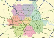
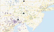
Warehouses, distribution centres, franchises, dealerships and sales people all have an area or territory that they serve. Territory management is the process of planning where to place sites, which ones to keep open or close, or simply working out which existing depot serves which customers or workloads most efficiently. Our solutions search automatically through hundreds of scenarios enabling users to identify ways to improve their service to customers while simultaneously minimising the costs to the business. And once the software investment is made, it can be used to optimise different areas of the business such as sales, not just logistics.
WLN – Can you give us some examples of current users of your territory management solutions?
For logistics use, we have supplied our solutions to Wincanton, Cormar Carpets, and BNP Paribas Real Estate, among others. Examples of where businesses optimise other types of territory include L’Oreal (sales team territory optimisation), Henkel (Merchandiser territories) and Home Instead (Franchise territory management). You can see some case studies about them on the next page.
WLN – What is driving your customers’ use of your territory management solutions?
We’re finding people are increasingly concerned with providing better value for money for their customers in order to retain them, and at the same time ensuring their service is financially viable. Customers are looking closely at greater differentiation and visualising the effect this will have on their operations. Many people we talk to are also rationalising and shedding non-core businesses, and mapping technologies help them plan their strategy for carrying through changes.
WLN – How do you start the conversation with clients?
 They usually approach us with a particular business challenge they need to address, and we then explore with them how they are currently working and what they wish to achieve. With many clients, as the first task is undertaken further opportunities for efficiencies are identified, which become the focus of future projects as our relationship develops. We’re unique in providing a mix of solutions addressing a range of issues, not just territory management or routing and scheduling.
WLN – There’s clearly an element of consultancy in what you do. Do you work with logistics consultants?
Yes, often. A company may have appointed logistics consultants to address their challenges, and as part of their action plan the appointed consultants will specify our technology. Or in some cases, we act as the client’s logistics analysts, running scenarios to help them identify the best ways forward.
WLN – Do you offer your own products exclusively?
We offer a mix of our own software and other suppliers’ applications as appropriate, working closely with the originators to achieve the ideal solutions for each customer.
WLN – Who are your target customers?
Our target customer is anyone who needs to allocate customers or workloads to a limited number of sites or resources. This can range from large FMCG manufacturers and logistics providers to consultants and individual transport management specialists. We help companies as they undergo change, to cope with the new realities more effectively and make informed decisions better and faster.
WLN – Can you talk us through your current territory management product offerings?
 Our key products are GeoXploit Logistics and OptiSite. GeoXploit Logistics provides a complete off-the-shelf mapping solution and includes all the maps, software, data and training you need to get started with territory management. You can also use it to generate automated customer distribution maps, drive times, and matrices of the nearest depots or franchises with the time and distance to each. GeoXploit Logistics saves money by optimising territories, improves customer service by calculating achievable delivery times, and sharpens communication with a wide range of management reports. GeoXploit Logistics links to vehicle routing and scheduling systems such as TruckStops VRS and so is used by many of our logistics customers to visualise routes, edit road networks and undertake strategic reviews of their operation.
Our second product, OptiSite, can work either within GeoXploit Logistics or with other versions of our GeoConcept mapping software. It offers enhanced modelling, using a sophisticated automatic least cost model to allocate work to resources, such as calls to depots. For example, it can take into account the relative drive-time costs per mile versus the investment needed to open, close or run additional depots or dealerships. OptiSite is usually a two-tier system, for example, depots and customers, but another version is also available to work on a three-tier model, for example manufacturing sites, regional distribution centres and customers.
WLN – You mentioned GeoConcept mapping software just now. What is it, and do you need it to run your other territory management offerings and take in other data?
GeoConcept is the core software engine that drives these territory optimisation solutions, so GeoXploit and OptiSite all have special menus within GeoConcept software. In January we rolled out our new GeoConcept 7.0 which is touch screen enabled, with a modern “Microsoft like” ribbon menu style and imports modern formats – Microsoft’s .XLSX (Excel spreadsheet) and .ACCDB (Access database).
WLN – Does GeoConcept 7.0 make your software easier to use?
![]() Yes, GeoConcept 7.0 means it’s now much easier to create, save, output and share reports based on analysis of maps and data. For instance, if you want to calculate optimised territories and then output a series of maps zoomed in to show each territory, these maps can all be generated and output in the desired format in a single process. Queries are also easier to create and more versatile. An example of a query might be” Find all those postcode sectors with over 20 customers, within 25 miles of my warehouse.”
Yes, GeoConcept 7.0 means it’s now much easier to create, save, output and share reports based on analysis of maps and data. For instance, if you want to calculate optimised territories and then output a series of maps zoomed in to show each territory, these maps can all be generated and output in the desired format in a single process. Queries are also easier to create and more versatile. An example of a query might be” Find all those postcode sectors with over 20 customers, within 25 miles of my warehouse.”
WLN – It sounds like your Territory Management solutions stand to benefit the whole organisation, not just the logistics department. Is that right?
Yes, indeed. Increasingly organisations are realising that their logistics department has information and analysis tools which they use to drive down their costs, but are also valuable for the whole business, and they can improve their overall efficiency by spotting gaps and areas where there are opportunities to concentrate market penetration and thus reduce the incremental cost of new customers at the same time as increasing turnover.
All the principles of territory management apply equally to sales people and service engineers as well as the distribution department, and can save time and money across the organisation.
The management team can also use our solutions to see gaps in their coverage that could be filled by a third party logistics partner, a new depot or merger with or acquisition of another organisation. Competitive pressure demands better customer service, so our solutions are also used to establish the real costs of different service levels, enabling companies to offer appropriately charged choices to their customers.
WLN – And do you think the green agenda is still important?
Certainly. Reducing mileage reduces emissions as well as reducing costs, so assigning customers, members or suppliers – pick-ups and deliveries – appropriately can make a significant difference. Our software is also used to visualise and plan claims on packs about the source of goods, for example not travelled more than a certain distance, sourced within county and so on.
WLN – Can your applications be tailored to clients’ needs or do they come as standard products? Are your solutions web-based or server based?
 Users can achieve substantial “tailoring” by the way they configure the wide choice of parameters available to them within the application. Most of this type of strategic work is desktop or server based rather than web based, as it can be computationally intensive. Dissemination of results/sharing information is where the web is good, and browser-based reporting is increasingly sought after.
WLN – How quickly can you supply your solutions? Do you supply full training?
For off the shelf solutions, the products can be supplied immediately and we have a full development team in-house, so bespoke or customised products can also be provided in a timely manner. There are regular public training courses each month for the core GeoConcept software, including territory management functionality. GeoXploit also includes free on-line training; for more sophisticated scenarios using OptiSite or Territory Manager, for example, the user might prefer an on-site implementation day or bespoke consultancy day to get the project started. Our support team also offer remote assistance using WebEx, so the customer can see our machine and we can see theirs as we discuss the best configuration or approach to using the software for their particular needs.
WLN – How flexible are your solutions as companies change?
Our solutions are modular. They can be tailored with different mapping data, and are scalable. For example, clients moving into a new part of the world can use the same core software with new country-specific data.
WLN – How quickly do you see a return?
The results are immediate. With any application, customers look for quick wins: people want to get going quickly, and we enable them to take the first step to deliver an immediate benefit, then look at their longer term concerns.
WLN – How are you organised to serve individual clients?
Each MapMechanics customer is assigned an account manager. Our sales team members each have different sector specialisations, but they are all familiar with the full range of products. As a result, the client solution may start in response to a logistics need and from there the customer may go on to look at the customer service and sales benefits it will bring.
WLN – Finally, where do you see MapMechanics going from here?
![]() We are increasingly going global. We need to provide international solutions to support our existing customers who are expanding into other countries, and we are getting new customers ourselves directly and through partners. We are now able to support this worldwide customer base with remote access and facilities such as webEx, in a way that was previously not possible.
We are increasingly going global. We need to provide international solutions to support our existing customers who are expanding into other countries, and we are getting new customers ourselves directly and through partners. We are now able to support this worldwide customer base with remote access and facilities such as webEx, in a way that was previously not possible.
MapMechanics for Logistics
Tel: 020 8568 7000


1 Comment
Hey that was really needful. Thanks for sharing. I’ll surely be looking for more.